Roselle
Tappa
Località
Roselle
The history of Roselle dates back to the Villanovan age. Over the centuries, Roselle became an ancient city-state, ruled by a king, another locumonia of central Etruria. During its rise, its clashes with the nearby Vetulonia were inevitable, and ended with the supremacy of Roselle. The founding period dates back to the 7th century BC. The city governed a large area spreading from the sea to Monte Amiata, fought in the war against Tarquinius Priscus together with other Latin people, and was then conquered by the Romans in 294 BC, becoming a Roman municipality. In 205 BC, it contributed to supplying grain and wood for Scipio Africanus’ fleet during the Second Punic War. Under the empire, it became a colony and enjoyed a period of great splendour, with the construction of the forum, the basilica, the amphitheatre and the thermal baths. A Bishop’s seat was erected in the 4th century.
The decline of Rusellae began in the 6th century, after it was invaded by Barbaric populations and lashed with malaria that made a poor, little-inhabited area from that period onwards. In 935, the city was attacked and destroyed by the Saracens and never rebuilt. While continuing to be a bishop's seat, Roselle was almost uninhabited, while down in the valley on the River Ombrone, the community of Grossetum began to form and grow in size. Pope Innocent II, who had spent time in Maremma between 1133 and 1137, decided to transfer the bishop’s seat to Grosseto, bestowing the title of civitas on the community. On 9 April 1138, Pope Innocent II issued the Sacrosancta Romana Ecclesia Papal bull, decreeing the creation of the diocese of Grosseto, and consequently the total decline of Roselle.
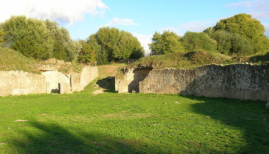
The ancient city of Roselle stood on an elliptical high plain with two hills separated by a central valley, the heart of the community’s political and religious life in all eras. Although there are no traces of people living there in prehistoric and protostoric periods, Roselle was urbanised by the Etruscans in the 7th century BC. The choice of this area for an organised settlement was not by chance. In fact, its high position gave it the natural possibility of defence and control over the current Grosseto plain, occupied in ancient times by Lake Prile, a large lagoon connected with the sea. The Etruscan city was conquered by the Romans in 294 BC, by the hand of the Consul Lucius Postumius Megellus The historian Livy (X, 37, 3) wrote about the conquest: “the army was moved into the Roselle area and not only was the countryside devastated, but the city was taken too; more than two thousand men were taken prisoner, a smaller number were killed inside the walls. In the 1st century AD, three centuries after the Romans conquered the city, Roselle was involved in intense building and monumental work, due to the protection by the emperor and the generosity of local powerful families. In the late Imperial Age, the city suffered the deterioration that affected Roman cities and in the Middle Ages, even though it was a bishop’s seat, it was reduced to a modest town, smaller in size than the one occupied by the Roman city, whose buildings were often taken and reused. In 1138 a bull by Pope Innocent II decreed the transfer of the diocese to the nearby Grosseto. From that moment on, Roselle suffered progressive abandonment and was reduced to...a wild solitude of stones and thorny bushes - the lair of foxes and wild boar, snakes and lizards - visited only by shepherds and herdsmen.... As described by George Dennis, a diplomat and scholarly Englishman in the 19th century, during his visit to Maremma in search of Etruscan antiquities. The Tuscany Superintendence of Archaeology has carried out research and restoration and optimisation work constantly from the 1960s to the present day.
Things to see:
1. ETRUSCAN NECROPOLIS “DEL SERPAIO” (6th century BC with subsequent reuse) The tombs are small hypogeum with square chambers, and entrance corridor, a jutting slab roof and a mound over the top of it. There is also a large tomb with a cylinder surrounding a wall with a rectangular chest that is the burial chamber.
2. TERME Dl ARZYGIO (4th century AD) Building used as public thermal baths. An inscription bears witness to its inauguration by Betitio Perpetuo Arzgio, the governor of Tuscia and Umbria between 366 and 370 AD.
3. DECUMANUS MAXIMUS (1st century AD) This is one of the city’s main roads, on an East-West axis. It starts from one of the gates that open in the perimeter wall and reaches the Forum. Buildings lined the road, as can be deduced by the thresholds that show where the entrances were, tubs and fountains.
4. HADRIAN’S THERMAL BATHS (120 AD) These were built during the Emperor Hadrian’s reign. Built in an L-shape, they also include a swimming pool (natatio)
5. CHURCH (VI-start of IX century A.D.) A church was built on top of the ruins of Hadrian's Baths in the High Medieval era, reusing pre-existing materials. A terraced cemetery surrounded the church.
6. WORKSHOPS (1st century AD) Some of the buildings on the Decumanus were used as craft workshops (tabernae); and in some cases there are still the rectangular shelves used to store the goods.
7. ETRUSCAN BUILDINGS IN THE FORUM AREA (7-6th century BC) The remains of the oldest Etruscan buildings can be found under the Roman forum’s paved floor: this so-called “building with perimeter” was one room with two perimeters - perhaps a place of worship - and the building “building with two rooms”, with two rectangular rooms, was also for public use.
8. FORUM (1st century BC) This was the Roman city’s main square, the community's political, religious and commercial centre. There were public buildings and temples built in honour of the gods and emperors around the square.
9. CARDO MAXIMUS (1st century BC) The eastern side of the Forum was bordered by a paved road, the cardo maximus, that was one of the city’s main roads, on a north-south axis. Grooves can still be seen along its axis, due to the passing of cart wheels.
10. BASILICA (1st century BC) This was one of the hubs of public life in the Roman era. Rectangular in shape, it had an interior colonnade, of which today only the base of one column is left. A raised platform (tribunal) hosted the magistrates who administered justice.
11. NORTHERN SIDE OF THE FORUM (1st century AD) In this area, beyond the dual portico, some buildings were constructed, including the Curia - used as a place for public meetings - and the Basilica dei Bassi - used for celebrations for this powerful local clan - which included a number of statues representing the members of the family, identified by the inscriptions. The space in front of it was the location of an Etruscan temple of which only the remains of a podium now remains.
12. SOUTHERN SIDE OF THE FORUM (1st century AD) The home of the Flamines Augustales, priests for the Empire’s worship, was accessed from the square. The building housed statues dedicated to the Imperial Julio-Claudian dynasty. The podium of a small temple dedicated to the god Augustus is next to it.
13. DOMUS DEI MOSAICI (1st century AD). It is an example of a Roman home with an atrium, with a central courtyard and basin for collecting water. The baths were in the southern area. To the west, overlooking the valley, there was a courtyard with a colonnade (peristylium) and a large swimming pool The rooms were embellished with mosaics or multi-coloured marble floors.
14. CISTERN (Imperial Roman Era). Used to collect water, it is lined with hydraulic mortar to waterproof the walls.
15. SOUTHERN HILL (3rd-2nd century BC) During the archaic era, there was a craftsman’s district in the south hill area Some kilns for firing pottery can still be seen. In Roman times, the hill was filled with houses, spread evenly along a cobble road.
16. AMPHITHEATRE (1st century AD) With an elliptical shape, that is characteristic of this type of buildings, it has four entrances, two outdoor and two with roofs. The central arena was bordered by rows of steps for spectators.
17. CASA ELLENISTICA (3rd-2nd century BC) We find the remains of a home with a central courtyard (atrium) and other rooms surrounding it, next to one of the amphitheatre entrances.
18. CASA DELL’IMPLUVIUM (6th century BC) This Etruscan building is square-shaped, with a courtyard in the centre, with a tub for collecting rainwater.
19. PERIMETER WALL (6th century BC) This encircles the slopes of two hills, with a total length of 3180 metres. The external vestments is made from large stone blocks, dry-built, and extracted just inside the city. There is a number of entrances along the wall, through which the main roads passed.
(sources: www.museidimaremma.it; Wikipedia)
Mappa
Grosseto
Strada Dei Ruderi
Grosseto
Strada Dei Ruderi
Grosseto